By Team ItsGoa
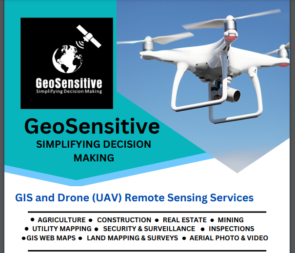
GeoSensitive is a GIS and Drone (UAV) remote sensing startup operating from FiiRE, a startup incubator based at Fatorda. Having begun operations in August 2022 as a Geographic Information Systems (GIS) services startup, this unique enterprise has over the past one year gone to provide its services to several big name private firms as well as a few government bodies at the state and village level.
A Geographic Information System (GIS) is a framework for gathering, managing, and analyzing spatial data. It analyzes spatial location and organizes layers of information into visualizations using maps and 3D scenes. With this unique capability, GIS reveals deeper insights into data, such as patterns, relationships, and situations, helping users to make smarter decisions.
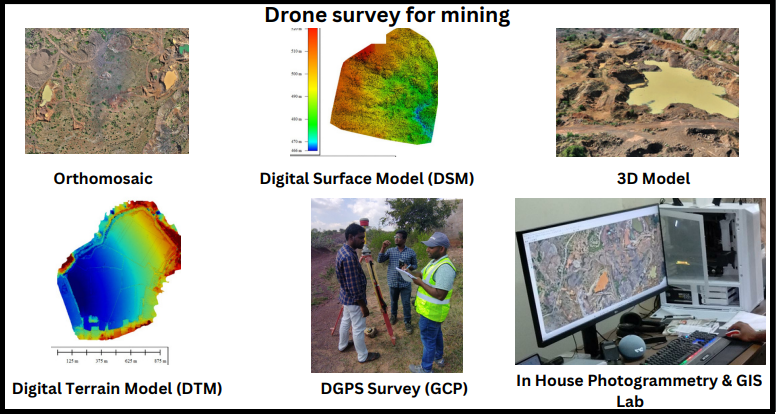
Drones are used to collect geospatial data using various kinds of payloads that the drone can carry. The data captured is then processed into outputs such as Orthomosaics 2D models, 3D models, contours, elevation models, vegetation indices, heat maps, etc. that provide specific insights about the site that is mapped.
In a brief conversation with ItsGoa, Malcolm Afonso, the founder of GeoSensitive shares more details about his startup, the various services it provides, the struggles that he faced while setting up his venture and lots more…
Excerpts
Tell us a bit about yourself
I am Malcolm Afonso. I am a native of Betalbatim, a village in South Goa. I started my career in the merchant navy as a trainee navigation officer but had to leave the industry due to a medical condition.
Post that, I joined the B.Sc. program at Parvatibai Chowgule College of Arts and Science where I fell in love with the subject of geology. I went on to pursue my Master’s degree in Geology from Goa University and was awarded the geology gold medal for the batch of 2015.
I cleared my CSIR NET exam the following year and joined the Department of Geology at Parvatibai Chowgule College as an assistant professor. During this period, I invested a great amount of time in learning about geospatial technology and created unique courses in these subjects that are taught at the B.Sc. level, only at Parvatibai Chowgule College.
After more than 6 years of teaching on a temporary basis, I got the opportunity to serve as a full-time assistant professor. However, my career as a government servant came to an abrupt end due to the enforcement of the reservation policy in the recruitment of faculty at the college. After this, I made up my mind to become my own boss and start my own startup where I can fulfil all my ambitions and life goals.
What inspired you to start this business? What was the idea that you had in mind when you decided to start this venture?
My first real experience of knowing that my skills and expertise are of value to the wider general public happened in the year 2019 when I created the people’s Coastal Regulation Zone plans for 69 villages across Goa by providing my expertise to a local NGO. Later, I got the opportunity to train the staff of the Directorate of Settlement and Land Records, Government of Goa in using open-source geospatial technology. I had also been lending my expertise to my own friends from across the world. A few researchers from Goa have also consulted me on their research projects.
There is a huge gap between what is possible with GIS and Drone technology today and its current implementation across various industries, which means that there is tremendous scope for professionals like me today and going ahead. As an entrepreneur, I am confident of catching the wave ahead of my peers.
What is the story behind the name of the start-up?
The name ‘GeoSensitive’ was coined by me as an expression of being sensitive to the earth, both literally and philosophically. By using drones and satellites, we can collect data about the earth’s features without touching it. All this data can then be used to understand and protect the planet, thus making us sensitive to its needs.
Tell us about the various services offered by your start-up
The services provided by GeoSensitive include:
1. carrying out detailed aerial photogrammetry surveys using UAV at the locations provided. The work involves collecting site geospatial data, processing the data, and producing 2D maps, 3D models, and contour maps etc.
2. conducting GIS mapping surveys based on client requirements.
3. customizing Android applications that geolocate and collect attribute data about features.
We analyze geospatial data to develop maps and reports.
Other services provided by the firm include:
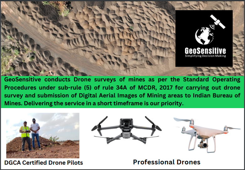
- Mine drone survey as per IBM compliance requirements.
- Industrial Drone Inspections.
- Mobile GIS data Collection/Surveying/Geotagging.
- Feature Extraction from existing maps/Geospatial database creation.
- DGPS Surveys.
- GIS Mapping.
- GIS Consultancy.
- Orthomosaic – High-resolution 2D mapping of the site prepared with drone data.
- Site Plan/Drawings Overlays.
- Natural Digital 3D Model of Site/City blocks/Hazardous Slope.
- Contour Mapping with Drone Photogrammetry.
- Point Cloud & Volumetric Analysis (Cut and Fill Analysis).
- Analysis of geospatial data to develop Web maps and reports.
- Aerial Photography and Videography.
What was the response from the public like when your enterprise just started off?
I was told by many people that there is no market for my services and that I will have to run the business without earning for a long period of time and would eventually run out of funds. I tried to showcase impactful case studies and promote the benefits of using GIS and drone technology to my local panchayat and zonal agricultural officers, but to no avail.
However, in the first month of setting up GeoSensitive, I got an opportunity to work on a pioneering initiative in Goa, which was the ‘Benaulim Plantation Drive 2022 with Geotagging’. Ever since then, my firm has gone on to deliver services for big real estate developers and construction firms. I have also provided my services to mining companies to help them complete the Indian Bureau of Mines’ Compliance Drone Survey.
My firm has also played a major role in the National Highway Monitoring Project. We have prepared map reports for researchers, found new use cases for land litigation lawyers, prepared a village agricultural map for a farmer’s organization, and also collaborated with professional photographers and cinematographers for drone shoots of corporate events, weddings and hotels. The list of new use cases delivered is growing each month.
Who are your major clients?
Our major clients include mining firms, real estate developers, property buyers and sellers, government agencies and administrative bodies at the state and village level, architects, earth moving/earthworks companies, lawyers handling property disputes, research scholars, agencies working in the environment/conservation management sector and hotels.
We also provide consultancy to other businesses to help them integrate GIS into their workflow.
Did you face any challenges while setting up this enterprise?
I have been fortunate to be able to set up the business with relative ease. I had to overcome my own mental blocks in the beginning.
How has FiiRE assisted you in scaling up your start-up?
At the onset, I knew that I had to be in an environment that would provide me space for unlearning, relearning and unleashing my creativity. On my first visit to FiiRE itself, I was convinced that this was the place I had to be at. The entire team at FiiRE has provided me with tremendous support in my entire journey so far and made me feel at home. I have received excellent mentorship through the mentor program here, which has given me practical and actionable insights into running my business successfully. I have also got opportunities to participate in personal business grooming sessions organized at FiiRE where we received training from national and international trainers in creating a business pitch and presenting our business.
What are your future plans?
To establish a bigger team so that we can cater to all the GIS and Drone Service needs that are emerging from Goa and beyond.
Finally, any message or words of advice that you would like to share with aspiring entrepreneurs in Goa?
On your journey, you will encounter people who will try to hijack your dreams by selling you hope of a stable income/certain lifestyle etc. Be confident in your abilities and don’t let anyone side-track your goals.
Way before starting this enterprise I found a passion for GIS, and dedicated lots of time and effort to understanding things that seemed unimportant/irrelevant at the time but I kept exploring different tools/software/programming languages out of curiosity and that has allowed me to be able to connect the dots. Deep domain-specific knowledge is good but for me to be able to deliver the goods I had to become a geologist who knows to work with GIS software, knows to read code and understands how several different technologies work and integrate with one another. This has given me an edge today.
For more information about GeoSensitive, visit:
Blog: http://geosensitive.blogspot.com/
Website: https://geosensitive.in/
Instagram: https://www.instagram.com/geosensitive/